This service searches the index of the records of the Second Surveyor's District of Tennessee for a single name and returns a list of all the surveys and entries where that person was the grantee. Copies of the surveys can then be ordered using service 2-SUR-2. A description of the records of the Second Surveyor's District of Tennessee and how to use them in your research is available. This description also includes complete example survey index searches as well as copies of actual surveys. Click here to order a survey index search.
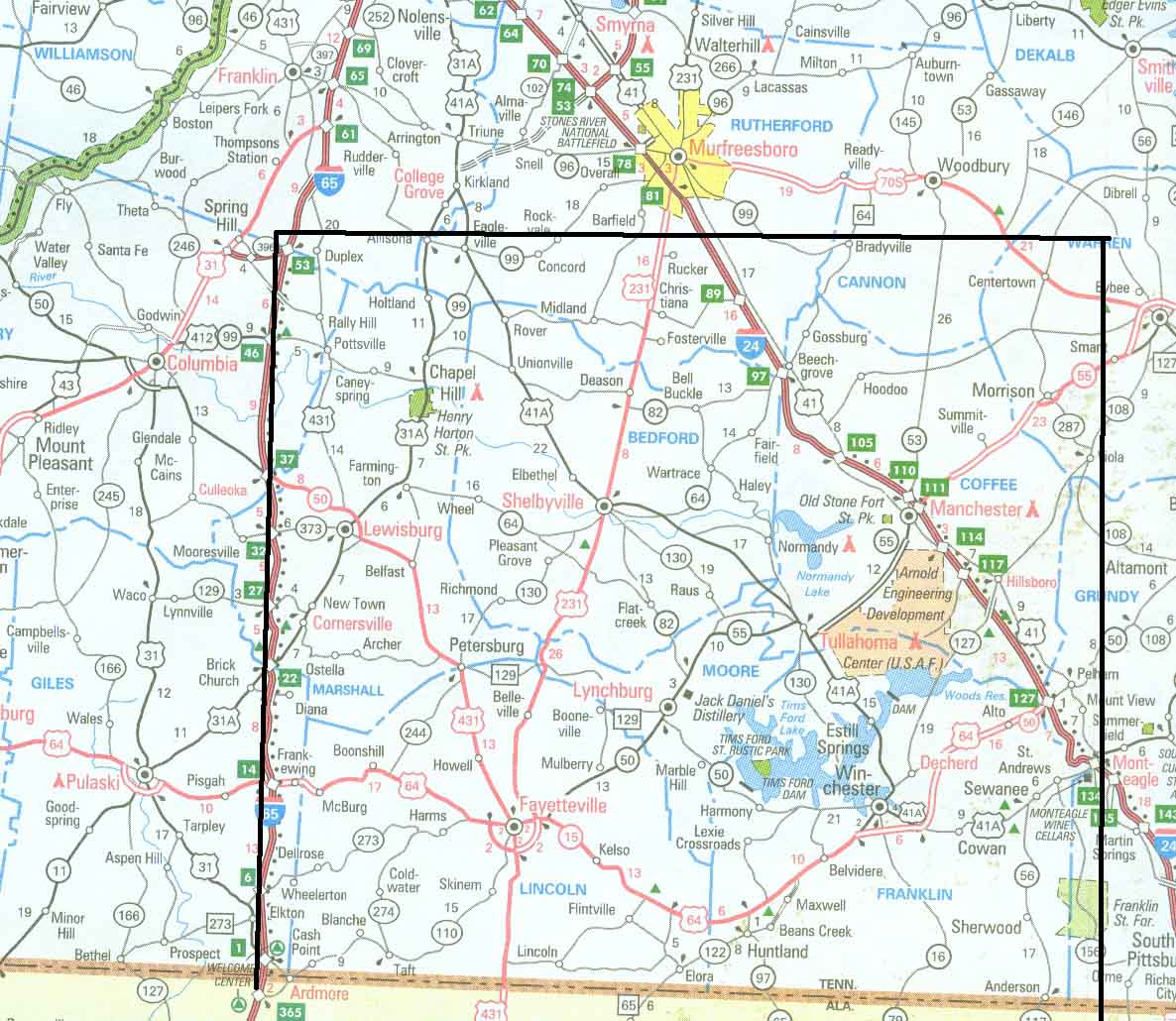
The records of the Second Surveyor's District of Tennessee are found at the Tennessee State Library and Archives (TSLA) in Nashville, Tennessee. Many of the records have been microfilmed by TSLA as part of series number 11 (Other Land Records), Record Group 50 (Early Land Records). The records of the Second Surveyor's District include a total of 9,091 surveys and accompanying plats. The records also include a corresponding entry for each survey, but these entries generally contain less information than the corresponding surveys. The dates of the records begin in 1807 and continue until about 1825. The Second Surveyor's District included most of the present-day counties of Marshall, Bedford, Coffee, Lincoln, Moore, and Franklin as well as parts of Rutherford and Giles Counties as illustrated in Figure 1..
Figure 1. Approximate location of the Second Surveyor's District
The records of the Second Surveyor's District include a total of 9,091 surveys and accompanying plats. The records also include a corresponding entry for each survey, but these entries generally contain less information than the corresponding surveys. The dates of the records begin in 1807 and continue until about 1825. There is a 244 page handwritten index to these surveys. It is the third volume recorded on Roll 24 of Record Group 50, and is therefore difficult and time-consuming to access and use.
Land grants are a well-known source for genealogical and historical research in Tennessee. A number of books have been published indexing North Carolina's grants and what is now the state of Tennessee as well as Tennessee's own grants. Unfortunately land grants themselves often contain little information of genealogical interest. A lesser-known source of information on early land history in Tennessee is the records of the Second Surveyor's District of Tennessee. While land grants typically contain little information of genealogical interest, surveys and accompanying plats contain the names of the chain carriers and/or markers for the survey. These chain carriers and markers were often relatives or members of families associated with the individual for whom the survey was done. Surveys also describe the location of the land and owners of abutting properties. Surveys also may identify the tract where a person "now lives", and this is important and distinctly valuable information far more interesting than just who owned (but may never have lived on) a tract.
The time period covered by these records (from 1807 until 1825) is one in which it is difficult to do research in middle Tennessee. The year 1807 was the date that the land covered in the records of the Second Surveyor's District was first settled following the cessation of Native American claims to that land by the First and Second Treaties of Tellico. Many early settlers did not record the deeds (or grants) for their land in county deed records. Therefore the only records that show they acquired the land are the entries and surveys of the Second Surveyor's District. The further, the information provided with these surveys is often a key to establishing that a family settling in Middle Tennessee was the same of family that moved from another state.
Today, the records of the second surveyors District are only available at TSLA. This microfilm in not in the LDS library system, so it is not widely accessible through local family history centers. No books have been written indexing or abstracting the records of the Second Surveyor's District.
The type of information found in plats and surveys includes:
An example of a Second District survey and the accompanying plat is shown in Figure 2.
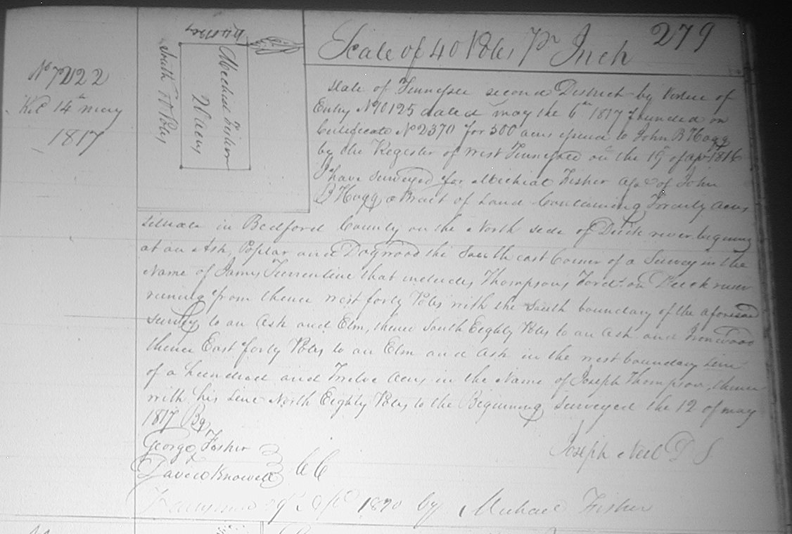
Figure 2. Example Survey and Plat
Although we ask you to supply a single individual name, in most cases we will also search and return to you all records for that surname in its various spellings. Table 1 shows the data you would receive by e-mail from a survey search on the name Michael Fisher:
| name | Book & Page | Acres | Location | Survey number | Date |
| John Fisher Jr. | C 253 | 150 | West fork of Elk | 1409 | 27 January 1809 |
| John Fisher | C 454 | 135 | West Fork of Rock Creek | 1697 | 30 June 1809 |
| John Fisher | D 236 | 50 | S side of Duck River | 2147 | 2 February 1810 |
| Michael Fisher | D 324 | 70 | Falling Creek | 2226 | 9 May 1810 |
| Charles Fisher | D 379 | 240 | S side of Duck River | 2350 | 16 June 1810 |
| Michael Fisher | E 560 | 50 | W waters of Rock Creek | 3291 | 23 November 1812 |
| John Fisher | E 561 | 70 | W waters of Rock Creek | 3293 | 17 October 1812 |
| John Fisher | E 568 | 55 | W waters of Rock Creek | 3302 | 17 October 1812 |
| Charles Fisher | E 656 | 240 | S side of Duck River | 3399 | 14 May 1813 |
| William Fisher | G 5 | 50 | waters of Rock Creek | 4384 | 13 August 1814 |
| Michael Fisher | G 44 | 25 | waters of North Duck | 4465 | 17 June 1814 |
|
Michael Fisher |
G 51 | 46 ½ | waters of North Duck | 4479 | 7 June 1814 |
| Joseph Fisher | G 102 | 10 | waters of west fork of Flint | 4586 | 9 September 1814 |
| Frederick Fisher | G 129 | 10 | Cedar Creek of Duck River | 4641 | 9 August 1814 |
| Frederick Fisher | G 130 | 40 | Cedar Creek of Duck River | 4644 | 9 August 1814 |
| John Fisher | G 132 | 8 | Cedar Creek of Duck River | 4647 | 11 October 1814 |
| John Fisher | G 462 | 28 | waters of Cedar Creek | 5364 | 10 November 1814 |
| John Fisher | G 462 | 4 | waters of Rock Creek | 5365 | 10 November 1814 |
| George Fisher | G 134 | 50 | waters of Cedar Creek | 4652 | 11 October 1814 |
| Michael Fisher | H 251 | 50 | Rock Creek of Duck River | 6035 | 18 July 1815 |
| Frederick Fisher | H 435 | 5 | waters of Cedar Creek | 6420 | 16 November 1815 |
| Michael Fisher | I 279 | 20 | North side of Duck River | 7222 | 12 March 1817 |
|
Michael Fisher |
K 418 | 6 | S side of Duck River | 8369 | 1 January 1820 |
| Michael Fisher | L 76 | 6 | Bedford County | 8734 | 16 July 1822 |
Table 1. Survey search example for Michael Fisher
The information in survey indices is not always accurate. Surveys may: not be indexed at all, mis-indexed to the wrong page number and/or book number, indexed under only one of a set of names (such as "Smith and Jones" is only indexed under "Smith"), or indexed under the wrong name entirely (such as under "Morton" rather than "Martin" or "Meaders" rather than "Medearis".)
Once a survey of interest is identified in the index or by a list of surveys returned by this search service, a copy can be ordered from us using the grantee, survey book letter, page number and survey number given in the index (see 2-SUR-2).
Before ordering, you should review the license agreement.
| GSC Associates Reston: 2727 Xanthia Court, Denver, CO 80238, +1-970-333-0802 (phone) E-mail: info@gscassociates.com |